|
||||||||||||
|
Villages and Towns in the 30's
|
At the time Hall visited the area, Sherbro lands were situated primarily in Bonth (Sherbro) District and parts of Moyambo and Bo Districts. The Sherbro were also divided into some 25 chiefdoms. At the head of each chiefdom was a Paramount Chief, assisted by a Chiefdom Council, also known as Tribal Authority. The Paramount Chief was chosen from candidates nominated by the royal clan or house, known as a ram. In cases where there were two or more royal houses, chiefly office rotated among them in turn.
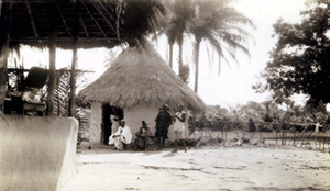 The rest house at Shengge Town. Three Fulani men relaxing in front of the town's rest house near the kitchen. |
Hall visited two Sherbro areas in 1936 and 1937. He wrote:
Because the time at my disposal was limited, I decided to confine myself to a study of the people in Sherbro [Bonthe] Island and the Chiefdom of Shenge (Kagboro), since, according to the most reliable information obtainable, the old Sherbro culture is best preserved in these two areas. The four months from December to March were spent in the Island. During April, a fortnight was spent in Bendu, on the mainland opposite Bonthe. From Bendu, the route, by motor launch, lorry, railway, and motor launch again, lay through Sembehu [Sembehun], Moyamba, and Rotifunk to Shenge town, which is situated on the western coast of the Chiefdom, about halfway between Bonthe and Freetown. In the Island transportation was by hammock and "gig" (rowboat) from Yoni near Bonthe, to Trisana at the western end of the Island. From there to Bendu, for Shenge, by motor launch along the northern shore of the Island. The last week of April, May, and all but the last few days of June were spent in Shenge.
Sherbro Island,
now known as Bonthe Island, contained two chiefdoms, Sitia and Ndema,
each with a Paramount Chief.
[top]
......................................
African Studies Homepage Sherbro Sitemap
Copyright
Info
For Inquiries